Research Focus & Projects
Research Focus
- Remote Sensing Methods
- Determining the Optical Properties of Coastal Waters
- Developing Optical Measurement Procedures

The Envisat satellite in Earth orbit. -image: ESA-
The colour of water, i.e. it’s spectral reflectance, is determined by the water constituents. Imaging spectrometer on board of satellites measure this Ocean Colour from space. The working group Optical Oceanography develops methods to derive biogeochemical and optical properties of seawater from Earth observation data. Emphasis is put on coastal waters, which are optically complex and ambiguous; besides water and phytoplankton, there is suspended matter and coloured dissolved organic matter from rivers too.
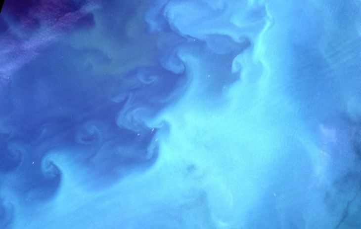
Satellite image of water structures in the North Sea.-image: Hereon-
In addition, the atmosphere influences the ocean signal significantly. Satellite data are evaluated by means of Artificial Neural Networks and other methods of Machine Learning. Global satellite data are made available and assembled in times series. Spatial and temporal patterns and changes of algae blooms and biogeochemical parameters are investigated based on these long time series data.
 with optical and other instruments is deployed in the water. <i>-image: Hereon-</i>")
A measurement platform (known as a rosette water sampler) with optical and other instruments is deployed in the water. -image: Hereon-
The way in which the light is absorbed and scattered in water reveals much about the type and quantity of materials present in the water. Dissolved organic substances (gelbstoff) and various single-cell algal (phytoplankton) pigments especially influence light absorption in water.
The department Optical Oceanography studies the optical properties in particular of coastal waters, but also in inland waters and oceans. In order to do so, absorption and scattering as well as the overall weakening of light in the water is measured. This provides a method for determining the concentration of certain water constituents. Conclusions about the water quality can thus be made. Scientists can then examine and improve theoretical ocean and climate models by incorporating the water quality variables.

An optical measurement system in the laboratory for determining the scattering of light by particles in the water. -image: Hereon-
The department Optical Oceanography also focuses on developing and optimising optical measurement methods and instruments.
The department, for example, presently works on high-precision devices with which light absorption through particles in water can be measured (PSICAM).
In addition, instruments are under development that measure the scattering of light in water.
Conclusions can be drawn from the measured values of absorption and scattering on the constituent components of the water, e.g. the phytoplankton groups in water.
Projects
AquaINFRA
The AquaINFRA project has received funding from the European Commission’s Horizon Europe Research and Innovation programme (2023-2026). The project aims to develop a virtual environment equipped with FAIR (Findable, Accessible, Interoperable und Reusable) multi-disciplinary data and services to support marine and freshwater scientists and stakeholders restoring healthy oceans, seas, coastal and inland waters. The AquaINFRA virtual environment will enable the target stakeholders to store, share, access, analyse and process research data and other research digital objects from their own discipline, across research infrastructures, disciplines and national borders leveraging on the European Open Science Cloud (EOSC) and the other existing operational dataspaces. Besides supporting the ongoing development of the EOSC as an overarching research infrastructure, AquaINFRA is addressing the specific need for enabling researchers from the marine and freshwater communities to work and collaborate across those two domains.
This is a KCO cooperation with the Helmholtz Coastal Data Center (HCDC).
For more information, please visit: aquainfra
PhytoDive
The diversity of phytoplankton and its productivity is investigated by means of Ocean cClour satellite data. The focus of research is put on global coastal waters. Important phytoplankton groups, of which some occur in Harmful Algae Blooms, shall be identified and spatially and temporally monitored.
Anomalies and changes of algae blooms will be investigated by utilization of operational and climatological satellite data. Important parameters for primary production and the associated carbon will be estimated.
Ocean Colour_CCI
ESA's Climate Change Initiative (CCI) aims at producing stable, long-term satellite-based Essential Climate Variables (ECVs) data products for climate research. The OC-CCI project focuses on Ocean Colour and creates global time series of spectral remote-sensing reflectance, chlorophyll concentration in water and inherent optical water properties. Basis are European and US American satellite data by ESA, EUMETSAT, NASA and NOAA. The group at Hereon is involved in the project since 2010.
Further information can be found on the OC_CCI website.
Completed Projects
EnMAP
The German satellite mission EnMAP (Environmental Mapping and Analysis Program) observes the Earth's surface in the visible and infrared spectral range. Analysis of the Earth observation data allows deducing information on the status of lakes, coasts and sea areas and enables monitoring of changes. In the frame of the scientific preparation for the EnMAP mission, scientists at Hereon develop new methods for analysing the hyperspectral data. The Department Optical Oceanography has been responsible for the preparation and development of measurement, recording and analysis methods for coastal and inland waters.
Further information can be found on the EnMAP website.
MyOcean II
“MyOcean II” was a project supported by the European Union that ran until September 2014. The main objective was the operation of an observational and forecasting system for maritime waters. The users of MyOcean II data stem from various sectors: shipping safety, ocean resources, marine and coastal protection as well as from climate and weather forecasting.
Data for the project was recorded using two optical measurement instruments (MODIS and VIIRS) on board a satellite. The department Optical Oceanography is responsible for developing a mathematical method regionally adapted for the Baltic Sea for analysing this recorded satellite data.
Further information can be found on the Copernicus website.
coastcolour
The Earth observation satellite ENVISAT obtained extensive data on the coastal zones. MERIS was one of the measurement instruments used during the mission. ENVISAT was abandoned in 2012 by the European Space Agency (ESA) after the satellite failed to respond to commands.
The ESA started the project “coastcolour” to further analyse and evaluate the collected data. It aims at exploiting the data’s potential to the fullest extent. All MERIS data is to be made available online at the coastcolour website.
The project also develops, examines and compares different globally applicable mathematical analysis methods for coastal water data.
The department Optical Oceanography is leading the scientific development and regional adaptation of these analysis methods.
Further information can be found on the
coastcolour website.
WIMO
Various impacts can be observed due to global climate change: rise in temperatures, alteration in marine fauna, harmful plankton blooms, a decrease in fish populations or changes in coastal properties of the North Sea. The increase in shipping traffic and offshore industry have also considerably impacted the ecosystem.
In order to shape utilisation of the German Bight sustainably, the WIMO (Scientific Monitoring Concepts for the German Bight) project alliance has been formed. The objective is to appraise the current condition of the German Bight.
WIMO initially identifies the relevant variables as well as their interactions in order to facilitate the actual description of the environmental condition. The next step is the regular and precise observation of conditions in the German Bight.
Information will be disseminated about this condition and quality developments in German marine regions. Furthermore, decision makers will obtain scientifically-based advice.
Information concepts for the public are developed and are presented in easily comprehensible formats.
Several departments at the Helmholtz-Zentrum Hereon are involved in WIMO.
The Department of Remote Sensing is developing what is known as a WebGIS for the project. This enables data from various measurement instruments in different data formats, which are currently distributed across different Internet servers, to be compiled and linked into one computer program.
COSYNA
COSYNA (Coastal Observing system for Northern and Arctic Seas) is overseen by the New Technologies Department of the Institute of Coastal Research at the Helmholtz-Zentrum Hereon.
The department Optical Oceanography integrates data from satellite measurements into COSYNA. Analysis and visualization methods for this data must be adapted for COSYNA requirements. In addition, results obtained from satellites are examined by comparing them to in situ measurements.
Further information can be found on the COSYNA website.
MaNIDA
MaNIDA (Marine Network for Integrated Data Access) is a Helmholtz-Zentrum Hereon initiative for developing and establishing a collective data portal for German marine research as a whole.
Several Helmholtz centres, universities and other institutes contribute to the initiative. The project at the Hereon is overseen by the New Technologies Department.
Further information can be found on the MaNIDA website.
OC-BPC
The EUMETSAT study on "Ocean Colour Bright Pixel Correction" was a cooperation of the group at Hereon with the French partners SOLVO and HYGEOS (2018-2019). The purpose of this project was to improve the operational atmospheric correction of Sentinel-3 OLCI data especially for extremely scattering – very bright – coastal waters.
C2X
The “Extreme Case-2 Water” C2X project was funded by the ESA. The objective was to study and advance the state of the art of atmospheric corrections and ocean colour algorithms for extremely absorbing and scattering Case-2 waters. These waters can be found in coastal and inland waters and are characterized by high concentrations of suspended matter or CDOM.