Research & Projects

FerryBox systems operated at Helmholtz-Zentrum Hereon. -Image: Wilhelm Petersen/Hereon-
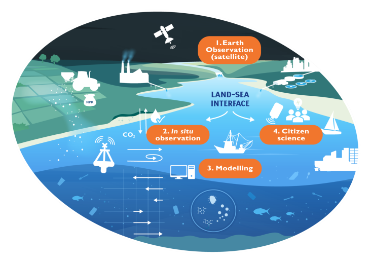
Most of our understanding of the processes in the marine environment is restricted to observations from single measurement campaigns (e.g. research cruises) during a certain period of time, or time series collected at a certain position (e.g. buoys). Comprehensive research and analysis of marine biogeochemical processes is only possible when observations from research vessels, remote sensing (radar, satellite) and fixed stations (buoys, poles) is combined. We use ships of opportunity, along with research vessels and fixed stations to investigate seasonal and regional patterns in biogeochemical parameters (primarily) in surface waters. When the frequency of measurements is high, we can investigate the effects of storms, tides, seasonal and interannual patterns on coastal and estuarine systems. We can also study how infrequent events (e.g. extreme floods or droughts) or long-term changes (climate induced changes, coastal ocean acidification, changes in pollution state) change the marine ecosystem.

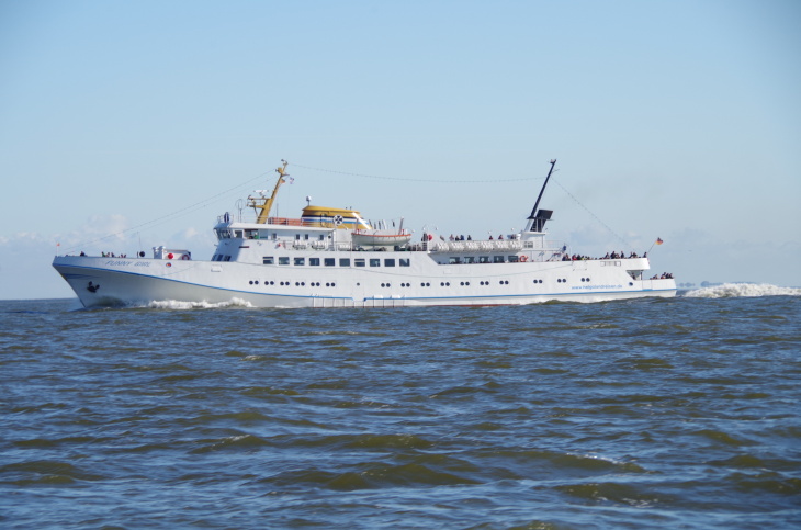
Installation of a FerryBox system onboard cargo vessel Hafnia Seaways. -Image: KD/Hereon-
The Department of Coastal Productivity uses data from FerryBoxes to carry out long-term water quality measurements in coastal regions like the North Sea, with a focus to the carbon cycle.
In order to ensure their reliability, the observations are first subjected to automated quality control before they are transferred to a database in real-time or near real time. Bottle samples for some parameters (e.g. dissolved oxygen, salinity, etc.), collected along the FerryBox routes, are analyzed in the lab, and then compared to the FerryBox measurements providing additional quality control.
Statistical methods like time series analysis, in combination with numerical models (including eco-system models), are applied to the long-term observations to study seasonal and regional patterns in the North Sea.
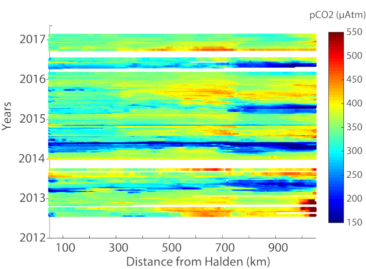
Time-series of pCO2 measurements along the transect from Halden (NO) to Zeebrugge (BE). -Image: http://ferrydata.hzg.de / Hereon-
Furthermore, a comparison of the FerryBox data to satellite data can be used to understand the larger spatial variations certain variables, such as chlorophyll-a.
Subtle changes in coastal waters, which can only be captured by continuous monitoring of marine processes over several years, can then be unraveled and assessed. Furthermore, these high-resolution long-term observations can provide the background to study in detail the impact of different scenarios (e.g. extreme events or climate induced changes) in marine ecosystems.
. Continuously measured pCO<sub>2</sub> (a) during the fall 2016 passages through the Skagerrak region using a showerhead equilibrator system (red) and a FerryBox (black/blue). Blue was used to identify the crossings with the highest pCO<sub>2</sub> values. Map of the restricted Skagerrak box (b) with the locations of the measurements shown in the respective color. Dissolved oxygen saturation (c) and NBS scale pH (d) measured by the FerryBox and shown in relation to the ship routes during fall 2016. <i>-image: KCP / Hereon-</i>")
Figure from Macovei et al. (2021a). Continuously measured pCO2 (a) during the fall 2016 passages through the Skagerrak region using a showerhead equilibrator system (red) and a FerryBox (black/blue). Blue was used to identify the crossings with the highest pCO2 values. Map of the restricted Skagerrak box (b) with the locations of the measurements shown in the respective color. Dissolved oxygen saturation (c) and NBS scale pH (d) measured by the FerryBox and shown in relation to the ship routes during fall 2016. -image: KCP / Hereon-
The integration of FerryBoxes on commercial ships allows to observe changes in surface waters on different scales: for example what are seasonal and yearly changes in salinity, temperature, dissolved oxygen, pH, algae. Regional characteristics, such as location and characteristics of water masses can also be identified. A study in the Skagerrak Strait between Denmark and Norway compared FerryBox measurements of pCO2 (black) against data from another ship in the ICOS network (red). The study found matching results when the journeys coincided (mid-September and end of October, 2016). However, when the FerryBox-equipped ship travelled on a more eastern route (blue), it captured a water mass with markedly different chemical signature (higher in pCO2, less oxygenated and more acidic), emphasising how dynamic the coastal marine environment can be.
See also Macovei et al. (2021)
 showing the spatial and temporal distribution of the data used to construct the Northwest European Shelf carbon budget for the year 2015, with FerryBox contributions displayed in red. <i>-image: KCP / Hereon-</i>")
. Diagram of CO<sub>2</sub> flux in the eastern North Sea calculated from FerryBox pCO<sub>2</sub> measurements. Positive (negative) values signify ocean CO<sub>2</sub> outgassing (uptake).<i>-image: KCP / Hereon-</i>")
. Temporal evolution of total alkalinity measured by the FerryBox in 2017 on the routes shown in blue and black colours, split into four longitudinal sections, showing the summertime increase in the areas influenced by the Wadden Sea. .<i>-image: KCP / Hereon-</i>")
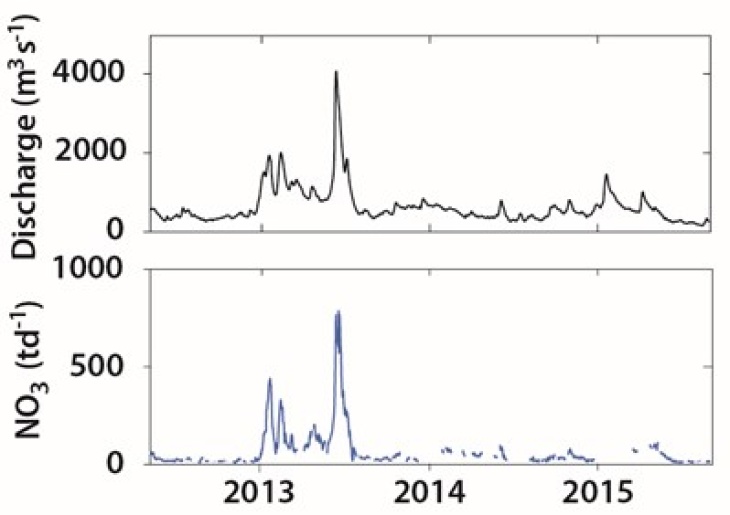
. Interpolated maps (left) were plotted from discrete data available in July 2013 (right) to estimate salinity and nutrient changes on the coast caused by the June 2013 extreme flood in the Elbe River. The flood delivered low salinity and high nutrient concentrations (high nitrate + nitrite) on large regions in the coast. <i>-image: KCP / Hereon-</i>")
. Dissolved oxygen (DO from a biogeochemical model) in July and August, 2013 decreased substantially in bottom waters in 2013, compared to ‘normal’ conditions measured in 2012. The study found that both hydrological and meteorological conditions contributed to this ecosystem effect, and resulting bottom water oxygen depletion.")
. Synoptization method applied for the June 2103 Elbe flood event and the data from the FerryBox-equipped ship travelling between Büsum and the island of Helgoland.")

Projects
- LandSeaLOT
- AQUARIUS
- SOOP
- NECO
- CARBOSTORE
- SEA-ReCap
- PhytoDive
- DANUBIUS-IP
- JERICO-NEXT
- NeXOS
- EnviGuard
- Yellow Sea
LandSeaLOT - Land Sea Interface : Let's Observe Together!
LandSeaLOT: Land-Sea Interface – Let's Observe Together! is a HORIZON Europe Research and Innovation Action (RIA) project, funded through EU Programme HORIZON-CL6-2023-GOVERNANCE-01-11.
LandSeaLot will link together in situ, model and earth observations (EO) and connect related communities, citizens and initiatives such as Copernicus, ESA, EEA, GEOSS, EMODnet and the European Digital Twin of the Ocean. These observations will be used in a gap analysis to co-design a common land-sea interface observation strategy and an implementation plan. LandSeaLot participants will simultaneously work on improving: in situ and EO capabilities, models to reduce the model/observations gap and the integration of model, in situ and satellite data. Observation capacity will be increased through tested, improved and guided use of low-cost technology by citizens, facilitated by the network of European marinas. The technologies selected will be piloted in LandSeaLot Integration Labs (ILs) together with improved and integrated in situ and EO observation techniques and model outputs. LandSeaLot ILs will cover selected areas in the Black Sea, Aegean Sea, Mediterranean Sea, Atlantic Ocean, North Sea and Baltic Sea, with a range of catchment, tidal and meteorological regimes. Experts and citizen science leaders will work in the ILs together with JERICO-RI, DANUBIUS-RI and ICOS-ERIC, and with regional policy makers and managers to tailor integrated observations that will provide them with information to manage societal challenges. These will include assessment of the lateral carbon flux and stock, plastics transfer, nutrients impact on primary production and eutrophication, supporting biodiversity conservation, improving modeling capability and supporting climate change adaptation (storm surges, floods, heat waves, coastal erosion, salt water intrusion). Relevant communities will be engaged by workshops, conferences, training, a high-tech summit and by a communication strategy including videos and policy briefs to ensure LandSeaLot’s legacy.
Hereon will lead work package 3 (Integrated observation and model frameworks) that focusses on developing, testing and benchmarking best practice for integrating observations and modelling capabilities to support modelling frameworks as a stepping stone to the development of digital twins of the land-marine interface. Hereon also has a prominent role regarding the North and Black Sea LandSeaLot Integration Labs, as well as for the development of a Joint Observation Strategy at the Land-Sea Interface.
More information can be found on the LandSeaLOT website.
Hereon EU Project Link
AQUARIUS Horizon Europe Project
AQUARIUS - Aqua Research Infrastructure Services for the health and protection of our unique, oceans, seas and freshwater ecosystems - is a four year Horizon Europe Project, funded by Research and Innovation Action (RIA) program HORIZON-INFRA-2023-SERV-01-01.
AQUARIUS will provide a highly comprehensive suite of integrated research infrastructures appropriate to addressing significant challenges for the long-term sustainability of our unique oceans, seas and freshwater ecosystems. For the first time, diverse research
infrastructures will be combined to facilitate the work of researchers and key stakeholders focused on challenges and opportunities for both marine and freshwater systems. An impressive range of 57 research infrastructure services will be made available to include research vessels, mobile marine observation platforms, aircraft, drones, satellite, sensors, fixed freshwater and marine observatories and test sites, experimental facilities, and sophisticated data infrastructures. AQUARIUS will support the development phase of the EU Mission to Restore our Ocean and waters by 2030, the Sustainable Blue Economy Partnership, the European Green Deal, and international climate initiatives. It will also be an essential component in achieving the European Digital Twin of the Ocean and the UN Decade for Ocean Sciences.
The needs of researchers will be met through a robust and transparent system of transnational access funding Calls, facilitated by centralised user-friendly access portal. The Call programme will be informed through stakeholder engagement and brokerage events.
Projects to be selected for Access must convincingly integrate multiple infrastructures and contribute to the core policy objectives of Mission Ocean, that is, to protect and restore marine and freshwater ecosystems and biodiversity; to prevent and eliminate pollution of
our oceans, seas and waters; and to ensure a sustainable, carbon-neutral and circular blue economy. A thematic and geographic focus will be the hallmark of the proposed transnational Calls, aligning with the Lighthouse Regions, that is, the Baltic and the North Sea Basins, Black Sea, Atlantic/Arctic, and Mediterranean Sea along with their associated rivers.
Hereon offers several of its research infrastructures for transnational access including to Cuxhaven and Tesperhude research stations, the Mobile Underwater Observatory in the North Sea (in cooperation with AWI), RV Ludwig Prandtl, the Elbe-GB-EcoHealthMonitor and the stable isotope lab in KCN.
Hereon EU Project Link
SOOP - Shaping Ocean Of Possibilities for Science-Industry Collaboration - is a Helmholtz Innovation Platform project, funded by the Helmholtz Association within the InnoPool program in 2023, in a collaboration between Hereon, AWI and GEOMAR.
SOOP is building an innovation platform for more ocean observation and technologies. New hardware and software will be used to collect oceanographic and climate-related data.
SOOP aims to support the development of new instruments, specifically modular sensors. These sensors can be deployed on non-scientific vessels, such as private sailboats, to collect oceanographic and climate-relevant data. The collected data will be made available on a jointly operated digital platform.These data can be used to create models of the ocean that simulate, for example, temperature, salinity, currents and other parameters. In this way, the scientists can provide indications of the state of the oceans and devise effective early warning systems.
In Work Package 3, we focus on technology development of a modular open source building kit (OSBK) for instrument systems, and on applications of this building kit for the field of ocean research with a focus on citizen science.
Further information can be found on the SOOPwebsite.
Hereon HGF Project Link
NECO - Natural hazards and marine ECOsystem response - causal linkage and predictability is a joint project between Germany and China, funded by the Federal Ministry of Education and Research (BMBF) in the research program "MARE:N - Ocean under Stress”.
The project NECO aims to understand how natural hazards impact coastal marine carbon cycling, in particular in triggering the formation and development of HAB and oxygen deficiencies, and how the impacts may change in response to future climate change and eutrophication. Based on the improved system understanding achieved in the project, we aim to provide a sound knowledge base and tools to assess the resilience of the North Sea (NS) and the East China Sea (ECS) ecosystems against impacts of natural hazards, and to improve our prediction skills of natural hazards and their impacts on coastal ocean carbon cycling.
Specific project objectives are:
1. Compilation and model-aided reconstruction of historical natural hazards and marine ecosystem response over multiple decades;
2. Identification and characterization of vulnerable regions in the North Sea and the East China Sea to the impact of natural hazards in terms of disturbances in marine ecosystem;
3. Process-based understanding of magnitude and spatial and temporal variability of carbon fluxes in coastal oceans driven by natural hazards, with particular attention paid to the development of harmful algal blooms and oxygen deficiencies;
4. Exploration of short-term (seasonal) and long-term (multi-decadal) predictability of natural hazards and impacts on carbon cycling in coastal oceans;
5. Knowledge transfer, organization of stakeholder dialogue and provision of policy recommendations.
We work in Work Package 1, 2 and 4, with support from in-situ observations and influence on carbon cycling from natural hazards and extremes.
CARBOSTORE - Carbon Storage in German Coastal Seas - Stability, Vulnerability and Perspectives for Manageability is a joint project funded by the Federal Ministry of Education and Research (BMBF) in the research program "MARE: N - Coastal, Marine and Polar Research for Sustainability” under the umbrella of the Research Framework Program“ Research for Sustainable Development” (FONA).
The main objectives of CARBOSTORE are to investigate and assess the stability and vulnerability of different carbon reservoirs in the North Sea and Baltic Sea, relevant pathways of carbon storage, and to predict their future evolution under different scenarios of climate change and anthropogenic alterations. Based on these vulnerability studies, and taking into account relevant legal as well as socio-economic frameworks, perspectives will be developed aiming at the targeted enhancement of carbon storage in the North and Baltic Seas, i.e., net negative CO2 emissions. In addition, decision-makers (e.g., government agencies) concerned with climate change mitigation will be supported with tools to implement and translate scientific results into management options.
CARBOSTORE is specifically dedicated to the "analysis of interactions of physically driven and biogeochemical cycles (in particular CO2-uptake/biological pumping) under the combined influence of global change and other directly anthropogenic drivers." This question is investigated for the two marginal seas North Sea and Baltic Sea, whose coastline partly passes through German territory.
Our work focuses on Work Package 1, The Pelagic Realm and Task 1.2, Separation of long-term total alkalinity (TA) trends from seasonal productivity patterns. In Task 1.2, the heterogeneity of the total alkalinity (TA) in coastal systems and its influence on region-specific buffer capacities and thus the overall capacity of the coastal sea to absorb carbon dioxide will be investigated. in particular, the effects of high TA on carbon uptake and storage in the water column will be studied in the southern central North Sea and Wadden Sea-Elbe region.
Carbostore Website
Underwater deployment of pump at Shkorpilovtsi station (IO-BAS) with FerryBox and pCO2 and pH measurements at the Black Sea coast.
SEA-ReCap: Research Capacity Building for healthy, productive and resilient Seas is a Helmholtz Association European Partnering project, which started in November, 2021. This project aims to further develop and strengthen the partnership between the Helmholtz-Zentrum Hereon in Germany and the Institute of Oceanology (IO-BAS) in Bulgaria, and supports the current and upcoming joint research and development activities. The western Black Sea and the North Sea are the two focus regions of the Helmholtz Partnership between Herepn and IO-BAS. The long-term objective of SEA-ReCap is to support the implementation of the Strategic Research and Innovation Agenda for the Black Sea (SRIA), and in particular the Knowledge-bridge pillar “Addressing f undamental Black Sea research challenges”. Together with HGF POF IV Topic 4 activities, this partnership will strengthen the capacity of IO-BAS with regards to new automated observation systems, implementation of novel modelling tools, integration of observational data and modelling results into scenario models, and applying those to joint research projects. SEA-ReCap’s approach is based on the analysis of existing data and knowledge, and interdisciplinary field campaigns and programs, which will employ novel measuring technologies, combined with the application of existing and novel coupled ocean models. Furthermore, the developed integrative and interdisciplinary framework will address the major challenges identified in both POF IV Topic 4 and the Black Sea SRIA.
SEA-ReCap work focusses on:
- Joint development of platforms and methods for integrated observations, predictive modelling tools, and novel system-analysis: contribution to joint development of the Ocean Observing and Modelling Systems;
- Establishment of science-based information streams and packages for different plausible and desirable future states of the two coastal-ocean systems: contribution to the knowledge base for evidence-based policymaking for sustainable use coastal marine ecosystems;
- Joint development of the ESFRI research infrastructure DANUBIUS-RI (The International Centre of Advanced Studies on River Sea Systems);
- Collaboration with IO-BAS in relation to joint H2020 proposal BG11 “DOORS (Developing an Optimal and Open Research Support system to unlock the potential for blue growth in the Black Sea)”, the funded H2020-CSA “Black Sea CONNECT: Black Sea Countries Come Together for Blue Growth”, and preparation of proposals in EU Horizon-Europe.
Our work focuses on research capacity building in operational oceanography, and specifically on application of FerryBoxes and instruments for carbonate system measurements, as well as building up capacity for integrated observations with Hereon and IO-BAS partners.
PhytoDive
PhytoDive: Diversity and phytoplankton productivity in global coastal waters is a project from the I2B Innovation, Information & Biologisation Funding, which is coordinated by Marin Hieronymi, KCO. The productivity of coastal waters is essential for fish and other aquatic organisms and is therefore an important component of the global food supply. The project started at the beginning of 2021.
The availability of global ocean color satellite Earth observation data over more than two decades offers an excellent opportunity to study phytoplankton diversity and productivity, and their changes. Available spectral data should enable the analysis of individual phytoplankton groups with the help of artificial intelligence. The main focus of this project is on global sea areas with the greatest ecological and social relevance - in the transition from the open ocean, the shelf areas to the coasts and the marginal seas. Important phytoplankton groups, which can also occur in toxic algal blooms, are to be identified locally and observed over space-time. With the help of operational and climatological ocean color data, anomalies and changes in flowers and species composition are to be investigated. Depending on the phytoplankton groups and regional circumstances, important parameters for climate studies such as the primary production of phytoplankton and the associated carbon cycle should be estimated. The results are to be validated and used in IfK cooperation and with national partners. The results are to be prepared for the modeling of marine biogeochemistry and the pelagic ecosystem. Possible anthropogenic causes for changes, such as rising water temperatures due to climate change, increased nutrient input from rivers or the construction of offshore structures, are to be analyzed. Corresponding effects for fisheries and aquaculture, but also for other interest groups should be communicated.
We work on Work Packages 3 and 4, with focus on primary production and carbon cycling. We investigate the role of coccolithophores and Noctiluca Scintillans species in collaboration with researchers in KCB and KCO.
DANUBIUS-IP
DANUBIUS-IP: DANUBIUS-RI Implementation Phase will ensure the successful implementation of DANUBIUS-RI (International Centre for Advanced Studies of River-Sea Systems) and support the successful operationalisation of DANUBIUS-ERIC and strengthen its role in coordinating all DANUBIUS-RI Components activities and services and demonstrating their attractiveness and agility to meet societal challenges (SDGs & EGD). The project will demonstrate DANUBIUS-RI`s capabilities and relevance by testing a selection of its scientific services under a unitary management to community through a dedicated call for a range of potential end-users. The activities in DANUBIUS-IP will: 1) assure the substantial role of DANUBIUS-RI in the European R&I landscape; and 2) foster the internal capability of the RI to become operational, providing prioritized services as evidence of the DANUBIUS-RI value proposition. The overall methodology for the first is based on further development of structure, governance and outreach to make the RI fully operational and to enlarge its community. The second is based on testing the scientific services to the community of users, and demonstrating the RI’s role, scope and operative capability. WP4 " Implementation Strategy of the DANUBIUS-RI Science and Innovation Agenda (SIA), DANUBIUS-RI Scientific Services and Commons" will co-led by Hereon (KCP) and University of Sterling/Scotland.
Further information can be found on the DANUBIUS_RI Germany website.
mehr
JERICO-NEXT: Joint European Research Infrastructure network for Coastal Observatory – Novel European eXpertise for coastal observaTories
The coastal area is the most productive and dynamic environment of the world ocean with significant resources and services for mankind. JERICO-NEXT (33 organizations from 15 countries) emphasizes that the complexity of the coastal ocean cannot be well understood if interconnection between physics, biogeochemistry and biology is not guaranteed. Such an integration requires new technological developments allowing continuous monitoring of a larger set of parameters. In the continuity of JERICO (FP7), the objective of JERICO-NEXT consists in strengthening and enlarging a solid and transparent European network in providing operational services for the timely, continuous and sustainable delivery of high quality environmental data and information products related to marine environment in European coastal seas.
The main objectives of JERICO-NEXT are to support European coastal research communities, enable free and open access to data, enhance the readiness of new observing platform networks by increasing the performance of sensors, showcase of the adequacy of the so-developed observing technologies and strategies, and to propose a medium-term roadmap for coastal
observatories through a permanent dialogue with stakeholders. JERICO-NEXT is based on a set of technological and methodological innovations. One main innovation potential is to provide a simple access to a large set of validated crucial information to understand the global change in coastal areas.
Furthermore, JERICO-NEXT provides coordinated ‘free of charge’ trans-national access to researchers or research teams from academy and industry to original coastal infrastructures operated by the projects consortium. This access opportunity is expected to help building long-term collaborations between users and to promote innovation and transfer of know-how in the coastal marine sector. Within this approach Hereon offers different research platforms including FerryBoxes, Gliders and cabled observatories (in cooperating with the Alfred Wegner Institute (AWI)).
Further information can be found on the JERICOnext website.
NeXOS: Next Generation Web-Enabled Sensors for the Monitoring of a Changing Ocean
The NeXOS project aimed to improve the temporal and spatial coverage, resolution and quality of marine observations through the development of cost-efficient innovative and interoperable in-situ sensors deployable from multiple platforms. This was achieved through the development of new, low-cost, compact and integrated sensors with multiple functionalities including the measurement of key parameters useful to a number of objectives, ranging from more precise monitoring and modelling of the marine environment to an improved assessment of fisheries.
These sensors are based on optical and acoustics technologies, addressing a majority of descriptors identified by the Marine Strategy Framework Directive for Good Environmental Status. All new sensors respond to multiplatform integration, sensor and data interoperability, quality assurance and reliability requirements. The sensors were calibrated, integrated on several types of platforms, scientifically validated and demonstrated.
Within the framework of NeXOS the Department of Global Coast has developed a Hyper Spectral Absorptions Sensor (HyAbS) optimized for an automated operation within flow-through systems such as the FerryBox, providing proxies of phytoplankton biomass, suspended particles in the water column and phytoplankton species composition. Additionally, a sensor for measuring parameters of the carbon cycle (pH, alkalinity and CO2) is under further optimisation in cooperation with Norwegian
partners.
Further information can be found on the NeXOSwebsite.
EnviGuard is a response to the growing need for accurate real time monitoring of the seas/ocean and the aquaculture industries need for a reliable and cost-effective risk management tool. The implementation of the EnviGuard system will allow for early detection of harmful algae blooms (HAB), chemical contaminants, viruses and toxins thus preventing economic losses. The modular EnviGuard system will be made up of three different sensor modules (microalgae / pathogens, i.e. viruses & bacteria / toxins & chemicals), that are connected to the common interface ‘EnviGuard Port’ which collects and sends the information to a server. The data will be accessible through a website in real-time. The biosensors to be developed in the project go far beyond the current state-of-the art in terms of accuracy, reliability and simplicity in operation by combining innovations in nanotechnology and molecular science leading to the development of cutting-edge sensor technology.
Within the framework of the EU project EnviGuard, the Alfred Wegner Institute (AWI) is further developing a biosensor for detecting different phytoplankton species for use in FerryBox systems. The biosensor will include automated sampling and sample processing. The Department of In-situ Measurements is contributing to the development of this biosensor by testing and optimizing the sensor for the autonomous use in connection to FerryBox systems and real time data transmission.
Further information can be found on the EnviGuard website.
Bilateral project China – Germany:
Cost-Effective Monitoring of Water Quality in the Northern Yellow Sea
The environment in the Yellow Sea, between China and the Korean Peninsula, has been dramatically impacted in the last few decades. These environmental changes are now to be continuously observed. To this end, the project “Economical Methods for Observing Water Quality in the Northern Yellow Sea" was founded and is supported by the Federal Ministry of Education and Research.
The Department of In Situ Measurements possesses an automated, economical measurement system for large-scale observation with their FerryBox system.
Together with the Institute of Coastal Research in Yantai, China, a ferry line in the Bohai Bay demonstrates the applicability of the FerryBox for observing water quality in the Yellow Sea.
Chinese scientists visit the Hereon for exchanging knowledge and for training in use of the FerryBox, whereas the Department of In Situ Measurements, with the aid of a portable FerryBox, operates various measurement campaigns on board a ferry in the Bohai Bay during different seasons.
The aim is to establish economical and continuous large-scale water quality observations in the Yellow Sea with the aid of FerryBoxes and other observational methods.