Tools
PFAS Explorer
The PFAS explorer serves as digital source of information and platform on different aspects of pollution with per- and polyfluoralkyl substances (PFAS). It targets starters in the scientific field and interested users from other areas.
Information was gathered on sources, distribution and fate of PFAS in different environmental compartments. Related concerns and potential ways forward are discussed from a scientific but also from a regulatory and political point of view.
Interactive "PFAS Explorer"
Microplastic Compendium
The Microplastic Compendium (MCP) amalgamates the current state of existing knowledge with regard to in-depth analysis of microplastics in the marine environment. Experts from the Helmholtz-Zentrum Hereon, the Helmholtz Centre for Environmental Research (UFZ), the Alfred-Wegener-Institute (AWI) and the University of Plymouth have contributed with content and special articles.
A compendium with information-rich information like this is created to address grand challenges to tackle global environmental changes, such as the pollution of the marine environment with microplastics.
Interactive "Microplastic Compendium"
Urban Air Quality Forecast for the city of Hamburg
The urban AQF Tool displays forecasted air pollutant concentrations for the region of Hamburg in Northern Germany based on a complex model developed at Helmholtz-Zentrum Hereon in Geesthacht, Germany. The tool considers various gaseous pollutants and different pollution sources for largely populated urban areas with intense harbour activities. A 100m resolution estimation and different charts are calculated to allow for easy access of current day conditions. To make the data easily understandable, the pollutant concentrations are summarized in the hourly indicator, the air quality index (AQI). The index uses a rank ranging from 1 (good) to 6 (poor) for total air quality.
This data collection provides a synthesis of current air quality issues in Hamburg and is intended to support action knowledge for decision-making. For detailed information on the air pollutants, pollution sources, the air quality index (AQI) and the usage of the tool, please visit the Storymap ‘Urban air pollution in Hamburg’.
Interactive "Urban Air Quality Forecast" Tool
Drift App
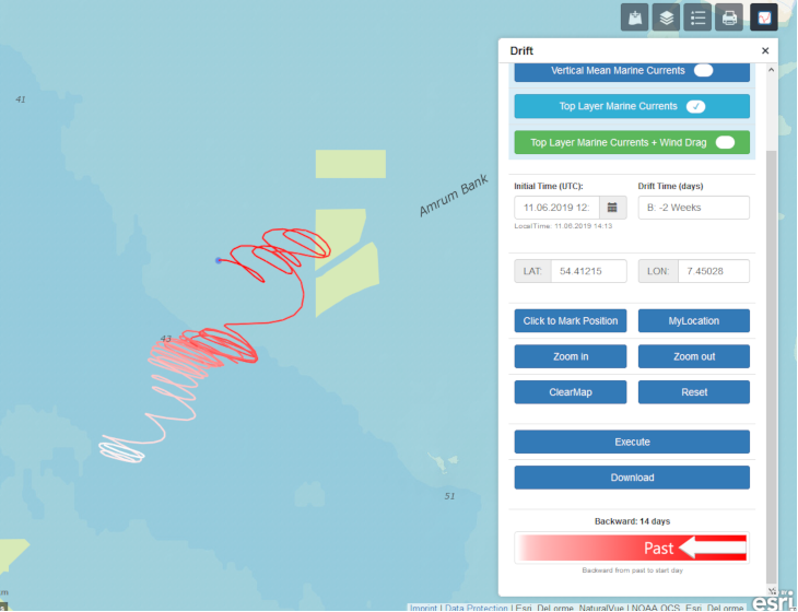
Knowledge of the history of the inverstigated waterbody is very important for a factual interpretation of sample data that is gathered at specific stations or during special campaigns. With this tool, drift paths can be calculated on the basis of operationally generated current fields (BSH).
InteractiveTool "DriftApp Tool"
Oil Drift
The deployment of chemical dispersants is an option to combat oil spills. An oil layer is dispersed into small oil droplets and mixed into the water column. The tool (Bayesian network) shows if dispersants should be used in case of an oil spill. You can see the probability that under changing conditions with or without dispersant the oil spill enters the German Wadden Sea.
Interactive Tool "Oil Drift"
Campaign metadata field app
Supporting automated processing of campaign data from the outset is a prerequisite for free access and realible flow of scientific data from the field to usable information.The Campaign Data Tool offers an opportunity to collect metadata and to store in-situ measurements using an electronic clipboard. In combination with external GPS devices, e.g. on board of ships, the Tool disposes high-accuracy in coordinates. Read about the field app and workflow