GCOAST Model System
COSMO-CLM (CCLM)

Grafics: M. Mathis/ Hereon
COSMO-CLM (CCLM) is non-hydrostatic limited-area atmospheric model (Rockel et al., 2008). The COSMO (cOnsortium for Small-scale mOdeling) model was initially developed by the Deutscher Wetterdienst (DWD, the German Meteorological Service) in the 2000s as a limited area weather forecast model. Later, it was developed further in the Climate Limited-area Modeling Community (CLM-Community) as the regional climate model COSMO-CLM. In December 2021, COSMO v6.0 was released, which is the last version of the COSMO model. With this release, the development of the COSMO model ended after more than 2 decades. The successor of CCLM is the limited area version of Icosahedral Nonhydrostatic (ICON) model (ICON-CLM).
TOCMAIM (Total Organic Carbon–Macrobenthos Interaction Model)

The model has been applied to the North Sea to investigate the spatio-temporal variability of macrobenthic biomass, sediment OC storage, benthic oxygen consumption and human impacts on sedimentary carbon storage. © 2024, Zhang, W. et al., CC BY 4.0. https://doi.org/10.1038/s41561-024-01581-4
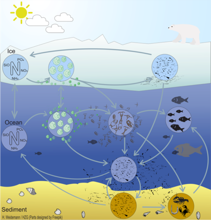
TOCMAIM (Total Organic Carbon–Macrobenthos Interaction Model) is developed at Hereon to resolve the interactions between benthic fauna and early diagenesis of organic carbon (OC). Sedimentary OC is divided into three pools depending on its degradability: labile, semi-labile, and refractory. With a Neumann boundary condition of OC fluxes at the sediment–water interface calculated by the pelagic model component (ECOSMO), sedimentary OC content is solved by a mass balance equation in TOCMAIM, taking into account the impacts of oxygen-dependent first-order degradation, macrobenthic uptake, respiration and bioturbation. Temporal change of macrobenthic biomass is calculated on the basis of food availability in the form of OC, temperature, oxygen, and mortality caused by predation and bottom trawling. Bioturbation scales with macrobenthic biomass and is inversely related to local OC resource. Oxygen penetration depth is jointly determined by physical (sediment permeability, porosity, bedform and bottom current velocity) and biogeochemical (carbon remineralization) parameters. TOCMAIM is integrated into the sediment module (MORSELFE) of the 3D hydro-morphodynamic model SCHISM, so that the information of erosion/deposition calculated by the hydro-morphodynamic model can be directly transferred to TOCMAIM to update the fluxes
Global Hydrology Model (HydroPy)
HydroPy (Stacke and Hagemann, 2021) is a state-of-the-art global hydrology model for which no model calibration was performed for its setup. HydroPy usually requires daily input fields of precipitation, 2m temperature, downwelling shortwave and longwave radiation, 2m specific humidity, surface pressure and 10m wind from the respective forcing dataset. However, it also comprises an option to use only precipitation and 2m temperature forcing. Recently it has been equipped with an initial implementation to calculate riverine nitrogen loads.
The model code and more information are available at https://doi.org/10.5281/zenodo.4541380
https://doi.org/10.5281/zenodo.4541380